Chom Ong Cave
Chom Ong Cave
The longest known underground network in northern Laos (≈16.5 km), accessible via the Khamu village of Ban Chom Ong, 45 km from Muang Xay. Trekking and speleology.
Chom Ong Cave is the longest known underground network in northern Laos, with an estimated length of approximately 16.5 km. Located in Oudomxay Province, 45 km from Muang Xay, it is reached after several hours on a dirt track and a trek from the Khamu village of Ban Chom Ong. The experience combines speleology, trekking, and immersion in a remote village with no electricity or cell phone signal.
Why visit Chom Ong Cave
Three elements set this site apart from other, more accessible Laotian caves. First, its sheer scale: an estimated 16.5 km of passages make it the longest known cavity in northern Laos, with interior volumes reaching 50 meters in height in places. Second, the underground river Nam Khang traverses part of the network, creating two distinct levels connected by a vast chamber 100 meters long. Finally, the visit is not limited to the cave itself: it necessarily includes a stay at Ban Chom Ong, a Khamu village that has developed a community ecotourism program since the late 2000s.
The site remains little-visited due to its difficult access, making it an option for travelers seeking a speleology and trekking experience off the beaten path.
History and discovery
The cave was officially catalogued in 2006 by the Oudomxay Department of Tourism during a survey of sites of tourist interest in the region. The Khamu villagers had long known it by the name Tham Chia, which means "bat cave." They exploited the accessible parts for three purposes: bat hunting, fishing in the underground river, and guano extraction used as fertilizer or as a component of gunpowder.
In 2009, a scientific team from the Northern Laos–European Caves project conducted the first precise measurements and documented 13.5 km of mapped passages. Subsequent explorations raised the total estimate to approximately 16.5 km. At the same time, local authorities implemented an ecotourism program designed to reduce village poverty: construction of a bamboo guesthouse, training of residents as guides and cooks, installation of sanitary facilities (toilets, shared bathrooms, ceramic water filters). An information sign was placed at the entrance and the cave was opened to the public.
What you see in the cave
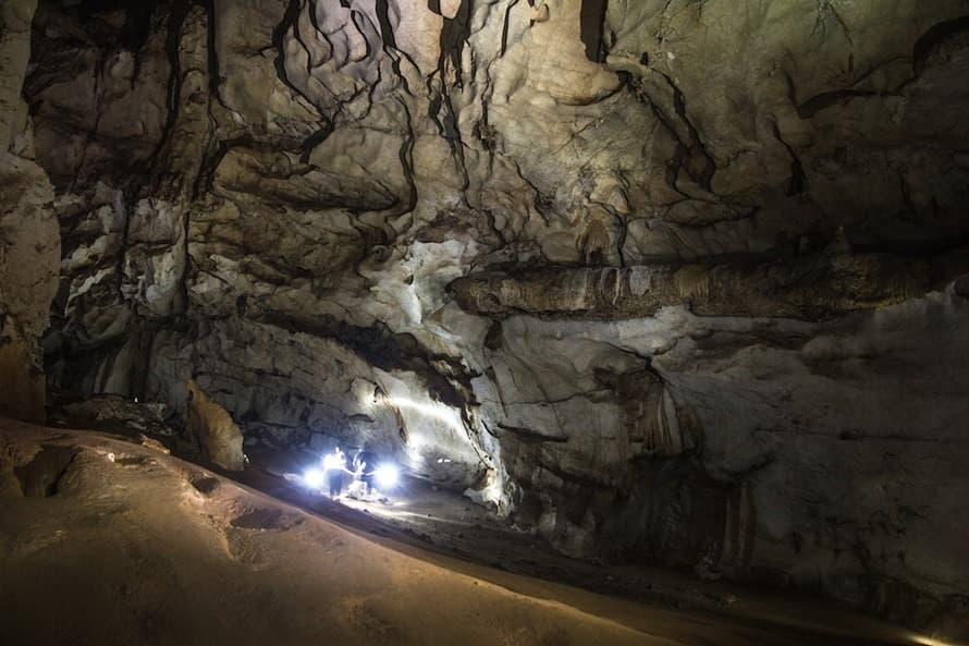
The cavity presents two superimposed levels. The fossil passage, approximately 15 meters above the river, forms what guides call the "balconies": an upper walkway from which you descend gradually toward the active section. The two levels converge in a vast chamber some hundred meters long.
Inside, you observe:
- the underground river Nam Khang, which traverses the lower part of the network;
- limestone formations (stalactites, stalagmites, draperies) of varying sizes;
- wide corridors and tunnels with ceiling heights reaching up to 50 meters;
- bat colonies, the origin of the local name.
Only a limited portion can be traversed without equipment. Beyond that, exploration requires a headlamp and accompaniment by a guide.
The village of Ban Chom Ong
Access to the cave necessarily passes through Ban Chom Ong, located 45 km from Muang Xay (approximately 40 km via dirt track). The village is inhabited by several hundred Khamu who live primarily from agriculture and, since the site's tourism development, from welcoming visitors. The houses are wooden, bordered by rice paddies and dominated by karst mountains.
An important point to anticipate: Ban Chom Ong has neither electricity nor cell phone signal. Accommodation is limited to a bamboo guesthouse run by the community, where you can also take meals. Villagers do not speak English; it is recommended to depart with an English-speaking guide from Muang Xay to facilitate exchanges.
Practical information
- Guide mandatory for the cave visit. Moderate fee, payable on-site in kip.
- Minimum time on site: 5 hours (round-trip trek to the cave from the village + visit), plus 1 to 3 hours to reach Ban Chom Ong from the end of the track.
- Recommended equipment: waterproof trekking shoes, headlamp, clothing that can get soiled (mud, wet areas), water and snacks.
- Required level: the outing includes climbing passages and slippery sections near the river. It is not suitable for occasional walkers or those uncomfortable in confined spaces.
- Cash: bring sufficient kip; no electronic payment options are available on-site.
- Hours: visits are generally organized during the day, to be coordinated with the guide upon arrival at the village.
When to go
The dry season, from November to March approximately, is the only truly suitable period. The track linking Muang Xay to Ban Chom Ong can be traveled in about 2.5 hours by motorcycle or 4x4. During the rainy season (June to September), the same road becomes very difficult or impassable, and certain sections of the cave may be flooded by rising waters of the Nam Khang. April and May are passable but marked by heat and sometimes the haze from agricultural burning.
How to get there
The starting point is Muang Xay (Oudomxay), accessible from Luang Prabang via national highway 13 then 2W (approximately one day), or by domestic flight. From Muang Xay, you take a rolling dirt track of 40 km toward Ban Chom Ong. The journey is by motorcycle or high-clearance vehicle, with a guide or driver familiar with the track. Allow approximately 2.5 hours in dry conditions. Once at the village, there remains 45 minutes to 1 hour of walking to reach the cave entrance.
Nearby
Oudomxay Province is a pivotal point between Luang Prabang and the northwestern part of the country. Travelers venturing to Chom Ong often combine their stay with a descent of the Nam Ou River, which flows through Nong Khiaw and Muang Ngoi, or with a return to Luang Prabang to browse the night market. Further southeast, the Hintang Archaeological Park offers another foray off the beaten path.
Frequently asked questions
Frequently asked questions
No. The access track becomes very difficult or impassable during the rainy season (June to September), and certain galleries can be flooded. The dry season, from November to March, is considerably preferable.
No, a visit with a local guide is mandatory. Only a small section is accessible without equipment, and the rest of the network requires accompaniment and a headlamp.
Allow a minimum of a full day from Muang Xay: approximately 2.5 hours on the track each way, one night at Ban Chom Ong in the bamboo guesthouse, and at least 5 hours on-site for the approach trek and visit.
No. The village has neither electricity nor cell phone signal. Inform your loved ones before departing and anticipate your needs (external battery, cash).
Not really. The route includes climbing passages and slippery sections along the underground river. Good physical condition and some trekking experience are recommended.
Plan your trip
Chom Ong integrates well into an extended northern Laos itinerary, away from the classic stops of Luang Prabang and Vang Vieng. To build a stay including this remote region, consult our suggested itineraries in Laos.
Interested in this visit?
We can include it in your personalised itinerary.